FAQs
What is a 205j Grant?
The Office of Water Quality manages two federal pass-through grant programs to improve water quality in the state: Section 319(h) and Section 205(j). The Section 205(j) program provides for projects that gather and map information on nonpoint and point source water pollution, develop recommendations for increasing the involvement of environmental and civic organizations in watershed planning activities and develop Watershed Management Plans (WMPs).
Why did you apply for the 205(j) Grant?
Vermillion County Soil and Water Conservation District identified a need for a WMP using historical data and the IDEM 303d impaired streams list. Other than previous work conducted on the Wabash River at the two fixed stations, there has been a lack of water quality sampling on the subwatersheds. This grant will help to develop critical areas within the watershed that will allow future projects to direct funding where the greatest need is.
Why did you choose this watershed?
Similar studies have been conducted and are currently being undertaken on watersheds surrounding the Mill Creek-Wabash River watershed. There needs to be more significant data for this watershed.
The limited studies that have occurred in this watershed have indicated that there are water quality concerns. The MC-WR watershed is listed on the Indiana Department of Environmental Management 303d Impaired Waters list.
Why is it this shape?
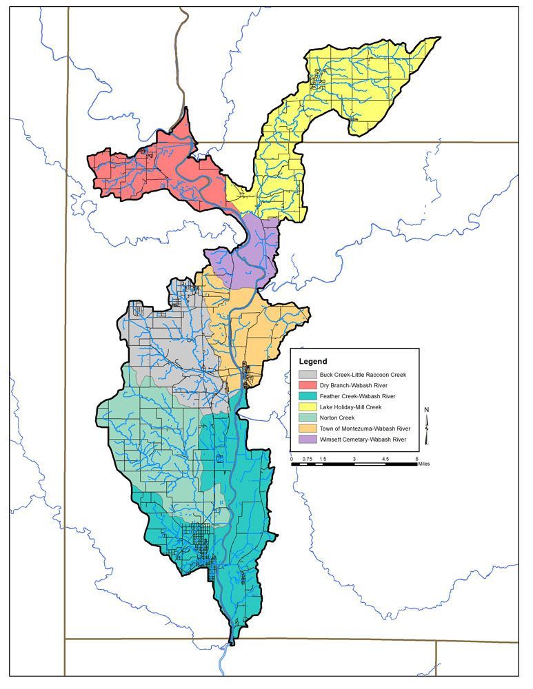
The topography of the landscape determines the shape of the watersheds. Larger watersheds are made up of smaller subwatersheds. The Mill Creek-Wabash River Watershed is made up of seven subwatersheds: Buck Creek-Little Raccoon Creek (Grey), Dry Branch-Wabash River (Red), Feather Creek-Wabash River (Teal), Lake Holiday-Mill Creek (Yellow), Norton Creek (Green), Town of Montezuma-Wabash River (Orange), and Wimsett Cemetery-Wabash River (Purple). All seven of these subwatersheds drain into the same stretch of the Wabash River, which gives the overall watershed its shape.
What are HUC codes?
The hydrologic unit code (HUC) is a numbering system for watersheds. It was developed by the U.S. Geological Survey (USGS) in cooperation with the U.S. Water Resource Council and the U.S. Department of Agriculture Natural Resources Conservation Service (NRCS). There are over 2,200 eight-digit HUC sub-regions in the United States, with 39 located in Indiana. The Mill Creek-Wabash River Watershed is a subwatershed of the Middle Wabash-Little Vermillion Watershed.
How did you choose sample sites?
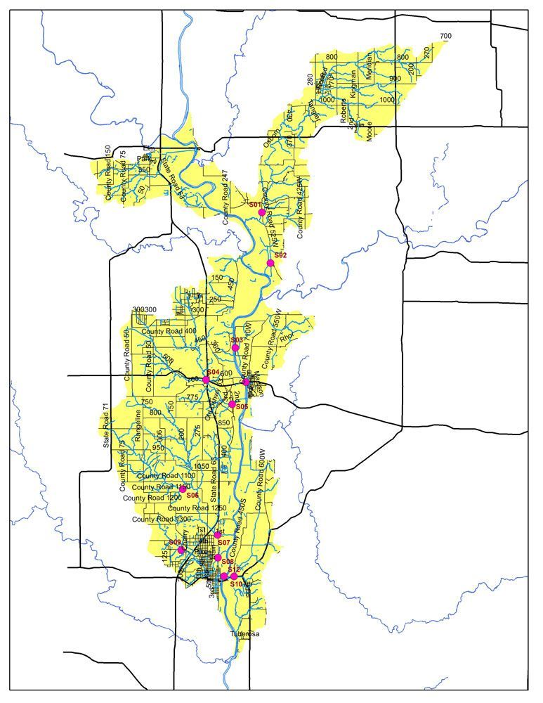
The sample sites were chosen at the Pour Points of each subwatershed. These pour points are the outlets of each subwatershed where they meet with the Wabash River. Sample sites at each pour point will allow us to collect discharge data for each subwatershed. The discharge data will help create critical areas the project will target to improve water quality.
Can we impact water quality on the Wabash River?
The project's goal is to impact water quality on a localized level. There are projects throughout the Wabash River Drainage area. Each of these watershed projects work to improve water quality locally, which will enhance the water quality of the Wabash River as a whole. This project will identify “critical areas” that are specific areas of concern within the watershed. The goal is to target the critical areas and work to reduce the impact on the watershed and improve water quality.
What will happen after this Grant is completed?
Over the two years of the 205(j) project, a Watershed Management Plan (WMP) will be created from water quality data and local landowner concerns. The WMP is a strategy and a work plan for achieving water resource goals that provide assessment and management information for a geographically defined watershed. Section 205(j) grants can only be used for water quality management planning and design. Once the planning and design are completed, entities can apply for a Section 319 Grant to implement the conservation practices outlined in the WMP.
How can I stay updated?
If you would like to stay updated on the project, there are a few ways:
- You can check out the Vermillion County SWCD webpage (vcswcd.com).
- The Vermillion County Soil and Water Conservation District Facebook page will have updates on the project as we move forward. We will also advertise events within the county and watershed on the Facebook page.
- An email list is being created for anyone interested in following along with the project. If you want to be added to that email list, contact billy-pigg@iaswcd.org, and he will add you.
- Attend any Public meetings, listening sessions, or other events.
How can I get involved?
- Join the Steering Committee meeting.
- Join our volunteer list to help with future water sampling, windshield surveys, clean-up events, and more.
- Become a Hoosier Riverwatch volunteer monitor – we’ll host the training and provide the equipment!
- Share your thoughts on the Mill Creek-Wabash River Watershed via email or phone at billy-pigg@iaswcd.org or 765-562-3856
- Send us data or photographs – how did this reach of the Wabash River, Mill Creek, and its tributaries look in the past?
- Share information about the Project with your friends, neighbors, and local groups. We’d be happy to talk with you and your group about the project.